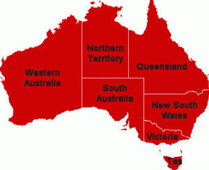
 Queensland is a state of Australia, located in the north-east of the country. It is bordered by the Northern Territory, South Australia and New South Wales to the west, south-west and south respectively. To the east, Queensland is bordered by the Coral Sea and Pacific Ocean.
The state is Australia’s second largest by area, following Western Australia, and the country’s third most populous after New South Wales and Victoria. The capital and largest city in the state is Brisbane.
Queensland was first occupied by Indigenous Australians and Torres Strait Islanders, who arrived between 40,000 and 65,000 years ago, according to various dating methods. Queensland was made a British Crown Colony that was separated from New South Wales on 6 June 1859, a date now celebrated state-wide as Queensland Day.
Queensland is often referred to as Australia’s Sunshine State.
Queensland’ current Premier is Anna Bligh of the Australian Labor Party.
The state was named in honour of Queen Victoria, who on 6 June 1859 signed Letters Patent separating the colony from New South Wales. At the time, Queen Victoria was a generally popular monarch, and she preferred an eponymous name for the new colony over Cooksland, which had been suggested by the influential local Presbyterian minister John Dunmore Lang in honour of English navigator James Cook.
Queensland is bordered to the north by the Torres Strait with Boigu Island off the coast of New Guinea representing the absolute northern extreme of the territory. The triangular Cape York Peninsula, which points toward New Guinea is the northernmost part of the state’s mainland.
West of the peninsula’s tip, northern Queensland is bordered by the Gulf of Carpentaria, while the Coral Sea, an arm of the Pacific Ocean, borders Queensland to the east. To the west, Queensland is bordered by the Northern Territory, at the 138°E longitude, and to the south-west by the north-eastern corner of South Australia.
In the south, there are three sections that comprise its border: the watershed from Point Danger to the Dumaresq River; the river section involving the Dumaresq, the MacIntyre and the Barwon; and 29°S latitude (including some minor historical encroachments below the 29th parallel) over to the South Australian border.
The state capital is Brisbane, located on the coast 100 kilometres (60 mi) by road north of the New South Wales border. The state is divided into several officially recognised regions. Other smaller geographical regions of note include the Atherton Tablelands, the Granite Belt, and the Channel Country in the far south-west.
Queensland has many places of natural beauty, including: the Sunshine Coast and the Gold Coast having some of the state’s most popular beaches; the Bunya Mountains and the Great Dividing Range with numerous lookouts, waterfalls and picnic areas; Carnarvon Gorge; Whitsunday Islands and Hinchinbrook Island.
The state contains six World Heritage listed preservation areas: Australian Fossil Mammal Sites at Riversleigh in the Gulf Country, Gondwana Rainforests of Australia, Fraser Island, Great Barrier Reef, Lamington National Park and the Wet Tropics of Queensland.
Content from this page is drawn from Here.

